研究テーマ / Research topic
インフラ設備外観点検に向けた計測計画
インフラ設備外観点検に向けた計測計画
研究背景
橋梁に代表されるインフラ設備の老朽化が世界中に社会課題になっています。設備の老朽化に伴い、設備にひび・錆などの異常が発生し、設備の安全に影響を及ぼし、事故に繋がる可能性があります。
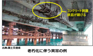
(橋梁老朽化の一例)
よって、インフラ設備の安全状況を把握・異常検知する「インフラ設備点検」を定期的に行う必要があります。近接目視点検は最も基本的な点検であり、作業員が近距離で設備表面を目視で確認する作業を指しています。大型機械を用いて設備付近にアクセスする必要がある為、膨大な費用・時間・人員がかかります。
そこで、我々はカメラを搭載した、UAV(ドローン)や地面ロボット、自動ジンバル雲台などの自律ロボットを用いた設備外観自動計測を行い、取得したデータから異常を検出するという、従来の近接目視点検と同等の点検を実現することで、点検の省人化・効率化を目指しています。
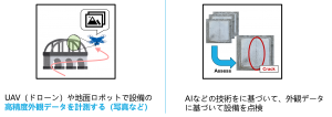
(一例:自律UAVを用いて設備の近接目視点検を行う)
ロボットによる外観点検システムは、この3つのコンポーネントを必要とします:
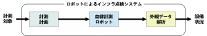
インフラ設備外観自動計測システム
- 計測計画:目標となるインフラを計測するに必要なロボット行動、制御計画
- 自律計測ロボット:上記の計画を実行するソフトウェア/ハードウェア
- 外観データ解析:設備外観における異常などをデータから検出
その内、私は外観点検に有用なデータを取得する為の「計測計画」に着眼します。
研究内容
本研究が考える計測はカメラを搭載したロボットで対象設備の外観データを取得することであり、計測計画の目的はデータ取得の為に自律ロボットが行うべき最適な「行動」、なるべき「状態」、所謂ロボットの最適な制御(Control)/ カメラの配置(Configuration)の集合を決めることです。
点検に向けたデータ計測にあたって、保証すべき最低限の指標は2つが存在する:
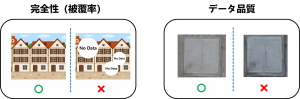
点検に使えるデータの要件
任意の1つ指標を満たしていないデータは 無効データ となります。点検に有用なデータを取得するには、センサの計測配置を適切に指定する必要があります。ここでの「計測配置」は、計測を行うセンサの各自由度の所望状態のことを指します。本研究が取り扱う自由度は「位置・方向・倍率」をいいます。
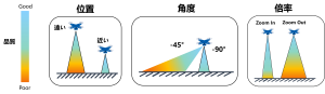
点検に使えるデータの要件
センサ配置のいずれの自由度におけるちょっとだけの変化でも、計測データの品質や、計測範囲の形状や広さを大きく影響を及ぼすため、所望の精度である対象全域のデータを計測できる配置の計画はかなり難しい問題であります。学術的に、この問題は「高次元多制約計画問題」に分類され、世界中の研究者たちは様々な着眼点から、如何により良い解(配置の集合)を導くかを研究して、次々と新しい方法を提案しています。
そこで、私はこの問題枠組みの中、下記の面を考慮した計測計画に関するアルゴリズムを研究しています:
- 計測作業効率化:いかに最短時間、最小のロボット移動量、最少の計測回数などで、与えられた目標インフラの点検データを取得するか
- 実用性の向上:実際の点検作業では、強風や障害物、GPS信号遮断により自律行動不可など、様々な外乱/問題が存在し、如何にこの状況で点検データを確実に計測するか
- 計測に用いる設備の選択:計測に使う設備(カメラやレンズ、ロボット機体など)の選択は計測作業の効率や成功率などに影響を大きく与えている。いかに計測タスクに適した設備を選択するか
研究実績
学術論文
- W.Wu, Y.Funabora, S.Doki, K.Doki, S.Yoshikawa, T.Mitsuda, and J.Xiang, “Evaluation and Enhancement of Resolution-Aware Coverage Path Planning Method for Surface Inspection Using Unmanned Aerial Vehicles,” in IEEE Access, 2024
- W. Wu, Y. Hong, Y. Funabora, S. Doki, and K. Doki, “Applications of Augmented Reality in Assisting Structure Surface Data Collection using Unmanned Aerial Vehicles,” in IEEE Access, 2024
国際学会
- Wu, W., Y. Funabora, S. Doki, and K. Doki, “The Impact of Equipment Specifications on the Efficiency of Visual Inspection using Unmanned Aerial Vehicles,” in 2024 10th International Conference on Control, Decision and Information Technologies (CoDIT), pp. 1505-1510, 2024
国内学会
- 呉偉桐, 舟洞佑記, 道木慎二, 道木加絵. 外観点検タスクと位置推定を考慮したUAV 群の経路計画法の検討. 令和元年度 電気・電子・情報関係学会 東海支部連合大会, 2019.
- 呉偉桐, 舟洞佑記, 道木慎二, 道木加絵. Efficient Multi-UAVs Path Planning for Cooperative Localization Based Inspection with Required Accuracy.機械学会東海支部, 2019.
- 呉偉桐, 舟洞佑記, 道木慎二, 道木加絵. 無人飛行体によるインフラ設備外観自動点検システムのための状態データの精度と作業効率を考慮した計測位置決定. 令和二年度 電気・電子・情報関係学会 東海支部連合大会, 2020.